GEM Airborne Solutions
Airborne Magnetometer and EM Solutions

High Precision GSMP-35A/25A Potassium Magnetometer // Airborne VLF Console with 2 sensors (containing 3 non magnetic air coils each)
The worldwide application of airborne magnetic and gradiometric data is growing, driven by demand for high-resolution, low cost data to:
- Map targets, geology and geologic structure in Mineral Exploration and Mineral Prospecting
- Perform frontier evaluation, augment seismic data in Hydrocarbon Exploration
- Detect Unexploded Ordnance (UXO)
- Map pipelines and other cultural objects in Environmental and Engineering investigations
- Map acquifers and faults in Groundwater work
To address industry requirements, GEM introduced the state-of-the-art Potassium, the
highest sensitivity magnetometer/gradiometer airborne system commercially available. It also features a number of other benefits, including maximum gradient tolerance and more.

High Precision Total Field Magnetic Data
GEM’s solution is based on a unique optically pumped Potassium sensor technology that offers an order of magnitude increase in sensitivity over other systems. It also provides:
- Reduced “heading” errors
- Highest absolute accuracy
- Decreased maintenance costs
These advantages plus GEM’s reputation as a proven supplier of advanced technologies make Potassium a key solution for your next airborne installation, including helicopter, fixed wing and UAV platforms.
Highest Sensitivity and Absolute Accuracy Magnetometers for Airborne applications
GEM’s airborne technology has been proven on Fixed Wing, Helicopter and UAV platforms. Part of its success is due to its components–specially designed for high resolution and noise-free data:
- Best Industry Warranty
- Proven Reliable
Airborne VLF – EM – Fast Cost Effective Mapping and Resistivity
GEM has developed many special units including one, two, and three sensor arrays such as its Tri-Directional Helicopter bird with Potassium sensors at the tips of a triangle. Shown below, the vertical Gradiometer and the Tri-Directional bird.

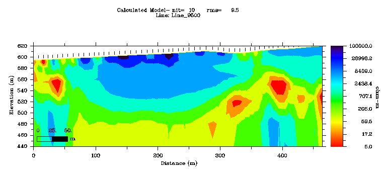
Airborne VLF Total Field Map VLF Calculated Resistivity Section
Helicopter Configurations
GEM has developed many special units including one, two, and three sensor arrays such as its Tri-Directional Helicopter bird with Potassium sensors at the tips of a triangle. Shown below, the vertical Gradiometer and the Tri-Directional bird.


GEM 2 Sensor Gradiometer GEM 3 sensor Triaxial Gradiometer
Horizontal gradient measurements are also increasingly popular for providing details about the lateral extent of subsurface anomalies located between survey lines. The Tri-Directional bird is an optimal solution for determining lateral extents.

Calculated Vertical Gradient Measured Vertical Gradient (shows enhanced detection capability of significant features)
Vertical gradients can assist significantly in identifying geologic/structural contacts and Nearsurface targets (UXO). Two-sensor birds such as the one shown in the first image on this page are ideal for this type of work.
GEM has a number of Fixed Wing clients–attracted to Potassium with its valued features and ability to acquire the highest quality data from an airborne platform.
The company is able to put together a fixed wing solution for your aircraft–including sensors, electronics, cabling, and training. We also provide an STC certificate, if required. Fixed wing surveys take advantage of the lack of microphony of the sensor, ultra-sensitivity and lack of heading error.


Eagle Geophysics’ Multi sensor Gradiometer, measures 10 vertical Gradients and several combinations of horizontal gradients.
Airborne Base Stations
High quality data are only obtained after reliable, accurate application of base station corrections. With GEM, you have the choice of working with two versions–the Overhauser or Potassium base stations. Both offer excellent value and a range of sensitivities that accommodates typical to highest resolution specifications. These implementations share a number of advanced features:
- Precise time synchronization of field and base station units using a built-in GPS option.
- Flexible scheduling.
- Manual start-up.
To learn more about GEM and its advanced line of airborne products, please contact us. We would be more than pleased to provide you with complete specifications or other information. Our World is Magnetics!

REQUEST A CALLBACK
If you would like to receive a callback from GEM Systems.
NEWS and EVENTS